


contres

lecmic
Gebruiker
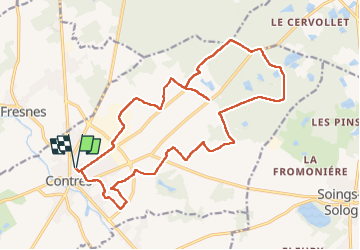

Lengte
20 km

Max. hoogte
127 m

Positief hoogteverschil
119 m
Km-Effort
22 km

Min. hoogte
98 m

Negatief hoogteverschil
119 m
Boucle
Ja
Datum van aanmaak :
2023-02-12 06:17:19.196
Laatste wijziging :
2023-02-12 09:44:56.285
3h27
Moeilijkheid : Gemakkelijk

Gratisgps-wandelapplicatie
 SityTrail
IGN / Geografische instituten
SityTrail Plus
De wereld gaat voor u open
Over ons
Tocht Stappen van 20 km beschikbaar op Centre-Val de Loire, Loir-et-Cher, Le Controis-en-Sologne. Deze tocht wordt voorgesteld door lecmic.
Beschrijving
sapeurs pompiers
l
Plaatsbepaling
Land:
France
Regio :
Centre-Val de Loire
Departement/Provincie :
Loir-et-Cher
Gemeente :
Le Controis-en-Sologne
Locatie:
Unknown
Vertrek:(Dec)
Vertrek:(UTM)
381663 ; 5253144 (31T) N.
Opmerkingen